 Manual Point Cloud Classification tool
|
|
This tool requires Global Mapper Pro |
The Manual Classification tool in Global Mapper Pro provides quick methods for manually applying classifications to selected point features. Classifications can be applied directly to currently selected points or continuously as points are selected in the workspace. Commonly used classifications are provided with button shortcuts, and all other classifications, including custom classifications created in the Configuration Menu, can be selected from the drop-down menu.
Find the Manual Classification tool from the Classification dropdown in the Lidar toolbar.
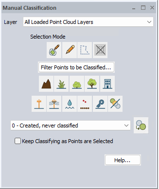
To use the classification buttons found in the Manual Classification tool, select a group of points then click on the button corresponding to the classification you wish to use. Checking the Keep Classifying as Points are Selected box will apply the currently chosen classification to points as they are selected in the workspace.
Points can be selected through any method in Global Mapper, including the Digitizer, Path Profile tool, or selected as the result of an analysis.
The Manual Classification dialog can be docked for ease of use. For more information, see Window Docking.
Layer
Choosing a layer from the dropdown menu will filter the classifications to only be applied to that one layer.
Selection Mode:
These tools can be used to select points. Note that manual classification does not prefer one method of selection over another.


![]()
Filter Points to be Classified...
This button opens Filter Lidar Points to filter which of the selected points receive the new classification.
Manual Classes
The built-in manual classification options available in the menu are:
Classify Selected Lidar Points as Ground (Class 2)
Classify – Vegetation Low
Classify Selected Lidar Points as Vegetation Low (Class 3)
Classify – Vegetation Medium
Classify Selected Lidar Points as Vegetation Medium (Class 4)
Classify – Vegetation High
Classify Selected Lidar Points as Vegetation High (Class 5)
Classify – Building
Classify Selected Lidar Points as Building (Class 6)
Classify – Transmission Tower
Classify Selected Lidar Points as Transmission Tower (Class 15)
Classify – Wire (Conductor)
Classify Selected Lidar Points as Wire (Conductor) (Class 14)
Classify – Water
Classify Selected Lidar Points as Water (Class 9)
Classify – High Noise
Classify Selected Lidar Points as High Noise (Class 18)
Classify – Model Key-point
Classify Selected Lidar Points as Model Key-point (Class 8)
Classify Selected Lidar Points as Unclassified (Class 1)
Additional Lidar Classes
Additional classes can be applied by choosing a class from the dropdown menu and clicking the Selected Classes button.
These additional classes are managed in the Configuration Menu.
Keep Classifying as Points Are Selected
Use this option to continuously apply a classification to points as they are selected.
First check the box to enable the functionality, then select the desired classification. While this option is enabled, all future selected point features will be classified until the option is disabled or the tool is closed.
Undo (CTRL + Z) can be used to undo classifications.
Use the Filter Points button to limit which selected points receive the classification.
 Classify – Ground

