Loading Data from a Spatial Database
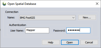
The Open Spatial Database dialog allows the user to select a previously established connection via the Spatial Database Connection Manager.
The Name drop-down list contains all of the spatial database connections that are currently defined.
Click the New. button to define a new spatial database connection. When the button is clicked, the Database Connection Dialog will be displayed. Once the new connection is set up, the name of that connection will be added to the list and become the selected connection.

Specify a Connection Name to identify the database, then enter the Database Information and Authentication info. Use the Test Connection button to check the connection, then press OK to save the new connection.
The User field specifies the user ID required to connect to the database. If the selected database connection has a predefined user ID, then that value will be displayed in this field. This value can be overridden, by typing in a different user ID. The stored database connection definition will not be changed.
Press Open to connect to the selected database.
For more information see Spatial Database Support