DTED
Import DTED
DTED files can be loaded directly, with the following common file extensions recognized by default:*.dt? (where ? is the level), *.avg, *.min, *.max, and *.mmm .
Export DTED
The Export DTED command allows the user to export any loaded elevation grid data sets to native format DTED files.
Export TIFF files from the File> Export menu by choosing Export Elevation Grid Format... and specifying DTED as the Export Format. Individual layers can also be exported from the Control Center by right-click on the layer and going to Layer > EXPORT. Multiple files can be batch converted to and from DTED format from the Batch Convert/Reproject tool.
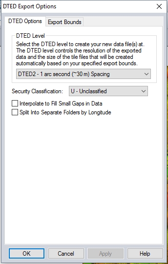
DTED Level
DTED files support a set of fixed resolutions (i.e. DTED levels) which are defined as aligning on particular boundaries. When you select the DTED level to export to and the export bounds, this defines which DTED tiles need to be generated to conform to the DTED standards for that level.
The filename that you select for the export is used as a base, with the lat/lon coordinates of the southwest corner of each tile appended to each filename as it is exported.
The supported DTED levels for export are:
- DTED0 - 30 arc second (~1 km ) Spacing
- DTED1- 3 arc second (~199 m) Spacing
- DTED2 - 1 arc second (~30 m) Spacing
- DTED/HRTE3 - 0.4 arc seond (~12 m) Spacing
Security Classification
Specify the security classification for the file from the following choices:
- U - Unclassified
- R - Restricted
- C - Confidential
- S - Secret
- T - Top Secret
Interpolate to fill small gaps in data
Any small areas with missing data will be filled in by interpolating the surrounding valid data using an IDW method. This is useful for filling small gaps between adjacent tiles or small holes in elevation data.
Split into Separate Folders by Longitude
This option will split up the exports by longitude into separate folders. The longitude is used as a folder name and the latitude is appended to the base filename for each exported cell.