CADRG/CIB/RPF
The Export CADRG/CIB/RPF command allows the user to export any loaded raster, vector, and elevation grid data sets to a new CADRG or CIB database. This export will automatically split the export into the appropriate zones and projection and create the a.toc (table of contents) file for the data, as well as the individual frame files as specified by the MIL-STD-2411 (RPF), MIL-PRF-89038 (CADRG), and MIL-PRF-89041 (CIB) specifications. A large number of defined chart types and scales/resolutions are available for export.
When selected, the command displays the CADRG/CIB Export Options dialog which allows the user to setup the export. The dialog consists of a General options panel (pictured below) which allows the user to select the chart type, resolution, and other parameters, and an Export Bounds panel which allows the user to set up the portion of the loaded data they wish to export.
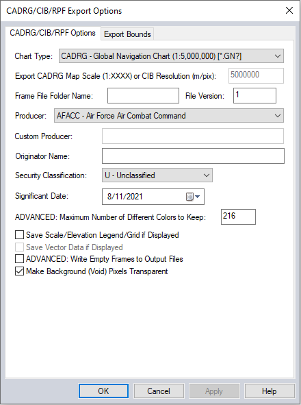
Chart Type - Choose from the following available chart types:
- CADRG - City Graphics (1:10,000) to (1:36,000) or Various (*.CG?)
- CADRG - Coastal Charts (Various)
- CADRG - Combat Charts (1:10,000) to (1:50,000) or Various(*.CM?)
- CADRG- Global Navigation Chart (1:50,000) (*.GN?)
- CADRG - Harbor and Approach Charts (Various)
- CADRG - Helicopter Route Chart (1:125,000)
- CADRG - Helicopter Route Chart Inset (1:250,000) to (1:90,000)
- CADRG - High Flying Chart - Host Nation
- CADRG - IFR Enroute Area (1:16,500,000) to (1:500,000)
- CADRG - IFR Enroute Low (1:1,000,000) to (1:4,500,000)
- CADRG - IFR Enroute High/Low (1:9,000,000) to (1:500,000)
- CADRG - Image City Maps (1:8,000) to (1:36,000)
- CADRG - Jet Navigation Chart
- CADRG - Joint Operations Graphic
- CADRG - Joint Operations Graphic - Air
- CADRG - Joint Operations Graphic - Radar
- CADRG - Low Flying Chart (Day)
- CADRG - Low Flying Chart (Night)
- CADRG - Low Flying Chart (TBD)
- CADRG - Military Installation Maps
- CADRG - Miscellaneous Maps & Charts (Various)
- CADRG - Naval Range Operating Area Chart (Various)
- CADRG - North Atlantic Route Chart
- CADRG - Operational Navigation Chart
- CADRG - Operational Planning Graphic
- CADRG - Range Charts (1:50,000) to (1:1,000,000)
- CADRG - Riverine Map
- CADRG - Russian General Staff Maps
- CADRG - SEC-Inset
- CADRG - Series 200 Air Target Chart
- CADRG - Special Military Map - Overlay (1:25,000) to (1:5,000,000)
- CADRG - Special Military Purpose (1:50,000) to (1:5,000,000)
- CADRG - Tactical Pilotage Chart
- CADRG - Topographic Line Map (1:24,000) to (1:200,000)
- CADRG - Transit Fly (UK)
- CADRG - Transit Flying Chart
- CADRG - VFR Helicopter Route Chart
- CADRG - VFR Sectional
- CADRG - VFR Terminal Area Chart
- CADRG - Visual Navigation Charts
- CIB - Imagery .5 meter to greater than 10 meter resolution
Export CADRG Map Scale (1:XXXX) or CIB Resolution(m/pix) - This option becomes available when the chart type specifies various resolutions. Enter the resolution value to specify the resolution in the output. The export will report the actual scale exported, rather than 'Various'.
Frame File Folder Name - specify the folder name of the frames
File Version - Specify the file version. File versions up to 1155 are supported.
Producer - The following options are available for producer, or use the custom producer below to specify a custom value:
- AFACC - Air Force Air Combat Command
- AFESC - Air Force Electronic Systems Center
- DCHMD - DoD Producer of Digital CHUM File Other than NGA
- DCHMF - Non-US (Foreign) Producer of Digital CHUM Files
- DCHMG - US Producer of Digital CHUM Files Outside DoD
- DCHUM - NGA Produced Digital CHUM File
- DMAAC - Defense Mapping Agency Aerospace Center
- DMAHC - Defense Mapping Agency Hydrographic Topographic Center
- DMARC - Defense Mapping Agency Reston Center
- DMASC - Defense Mapping Agency Systems Center
- NONDD - US Producer Outside the Department of Defense
- NONUS - Non- US Producer
- OTHER - Other Unspecified Producer * Allows specifying a custom producer in the field below
- PACAF - Pacific Air Forces
- SOCAF - Air Force Special Operations Command
- SOCOM - United States Special Operations Command
- USAFE - United States Air Force, Europe
Custom Producer- When selecting OTHER from the Producer list, this field will be enabled. Whatever is typed there will be stored in the header block associated with "Producer" in FalconView. If the user chooses a Producer other then OTHER, or leaves the Custom Producer field blank, the Producer abbreviation from the drop-down list will be stored in the file.
Originator Name - This field is stored in the header file.
Security Classification - Choose from the following options:
- T - Top Secret
- S- Secret
- C- Confidential
- R - Restricted
- U - Unclassified
Significant Date- Type the date into this field, or select the date from a drop-down calendar. The value that you enter here will be stored in the file metadata. (The Production Date, set to the current date, will also be stored in the metadata).
ADVANCED: Maximum Number of Different Colors to Keep - This is an advanced setting recommended for experienced users. This allows you to reduce the number of significant colors considered, to possibly enhance the presence of small features using colors not found in the rest of the map.
Save Scale/ Elevation Legend/Grid if Displayed - The elevation legend and scale will be saved in the export if visible on screen.
Save vector Data If Displayed - Vector data will be saved to the chart
ADVANCED: Write Empty Frames to Output Files - This option will create empty frames in the export result.
Make Background (Void) Pixels Transparent - Enabling this option will make any background shown in the export transparent.