When a single area, line, or point feature
is selected, there is an EDIT option on the right-click popup menu allowing
you to edit that feature (i.e. EDIT-Area Feature, EDIT-Line Feature, or
EDIT-Point Feature). Additional menus are available for editing the attributes and styles of selected features, in addition to performing analysis and measurement functions in the right-click Digitizer menus.
Selecting that option displays the Modify Feature Info dialog which allows you to modify the Name, Feature Type, Drawing Style, and Attributes for the selected feature. You can also access this dialog by double-clicking on a feature.
For additional options, select the feature with digitizer and right-click to Attribute/ Style Functions options to access the menu (see below).
Allows you to copy Attributes from one feature to another. This displays a dialog that allows you to select which types of selected/loaded features to copy attributes between and which attributes to copy. For more information see Adding Attributes to Features from Other Features
Adds and updates
the Measure Attributes of selected feature. Useful for when vertex, line
or area features have been edited and Measurement values need to be recalculated.
Select
area feature to add a count of point and line features in the selected
area feature as an Attribute to the selected Area Feature. The new Attributes will appear as POINT_COUNT for contained points
and LINE_COUNT for contained lines.
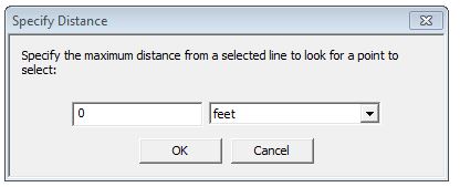
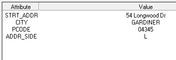
With a road data set loaded, select points to add the address information from the roads layer to the points. Once selected, you will be asked to define the maximum distance the point feature can be from the line feature to copy the address from it in the Specify Distance dialog (below).

A pop-up message will confirm that the Address attribute(s) have been added
to the selected points. Clicking the modified point with the Feature Info
Tool will confirm that the Road information has been successfully added
to the point.

Will add
a coordinate attribute to selected feature.
Adds an Attribute
for Point, Line or Area Style.
When elevation data is loaded, will calculate Elevation/Slope Statistics for selected features.
This allows you to create a new attribute value (or update an existing one) by copying the value of some attribute, performing a mathematical operation either between two attributes or an attribute and some number, or to append some text string to a value when Simple Calculation is selected.
The dialog below is displayed when you select this option to allow you
to set it up:

Selecting Use Formula Calculation
option enables the use of additional formulas.
Available Attributes: User may
select an attribute to insert into the current formula (use the Insert
button to the right)
Available Functions: User may select
a function template to insert into the current formula, which includes
the function name and dummy parameters where they're expected. Insert
the function using the button immediately to the right. Changing the current
function in the list displays a function description in the read-only
control directly below the function selector.
Enter Formula to Use: An edit control
where the user types in the formula that they require.
Insertions from the Available Attributes and Available Functions drop downs
determine the current insertion point in this control, and replace any
current selection. As changes are made to the formula, a status is updated
in the Status control immediately below.
Status: Indicates the status of the current formula. If the formula is non-empty, it is evaluated for correctness. If there is no error, then the status will be 'OK'. Otherwise, if there is an error an indication of what the error is displayed. In addition, if there is no error, then the dialog used the current feature in whatever feature collection is being considered to evaluate the value that the formula would compute, as a sample. This is shown below the status.
Use the 'Insert' button to the right of the selected Function to insert a function to use and the 'Insert' button to the right of Available Attributes to add the Attribute name to the string. If the formula is invalid or empty, the 'Calculate' button is disabled. Clicking 'Calculate' will apply the formula to the feature collection.
Choose this option with points
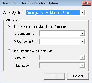
selected to create a Quiver Plot. The Quiver
Plot (Direction Vector) Options dialog (below) allows the user
to specify the arrow symbol and attributes to be used when displaying
point data as a quiver (arrow) plot. The arrow will point in the
direction calculated from the attributes. The size of the arrow
will be scaled relative to the largest magnitude value. If no magnitude
is specified, all of the arrows will be the same size.
Specify the symbol to use by choosing an arrow
symbol from the Arrow Symbol list.
Use a UV Vector - When this option
is chosen, the specified attributes must contain a UV vector. The
U component is the vector value in the X direction. The V component
is the vector value in the Y direction. These two values will be
used to compute the direction and magnitude of the vector.
Use Direction and Magnitude - When this option is chosen, the user must choose an attribute containing the direction (in degrees, relative to 0 pointing at the top of the map, drawn clockwise), and another attribute containing the magnitude. The magnitude is optional.
Requires elevation data (like
a DEM) to be loaded into the workspace. The elevation of the top most elevation layer will be applied to the selected feature at each vertex. The elevation value of the feature will be applied using the resampling method of the top most terrain layer. For elevation layers the resampling method is bilinear interpolation by default, so the elevation at each vertex will be calculated using bilinear interpolation.
Change the interpolation method in the display settings of the top most elevation layer to apply elevations using a different method of calculation.
Will load local files or a URL
referenced in an Attribute of Selected Feature.
When a point, line or area feature with a label is selected, tho option may be used to quickly change the color of the label's text. Selecting this option will populate Global Mapper's color picker.
When you add or edit new attributes, the dialog
that appears includes drop-downs for both the attribute name and value
showing previously entered names and values for easy selection. These
values are stored in an easy to edit text file named attr_previous_vals.txt
in your setting file path (see Help-> About dialog for this location).
The format is described in the file so you can set this up initially with
values for particular customers if you don't want to wait to have it filled
in as it's used. When more than one area, line, and/or point feature is
selected, there is an option on the right-click popup menu allowing you
to edit the selected features. Selecting that option displays a dialog
which allows you to modify the Name, Feature Type, Feature Layer, and
Drawing Style, and Attributes for the selected features.
*When editing multiple features, if some features use a custom description and others do not, the box will be filed with a light grey check mark and the text field will be empty and disabled. Checking or clearing the check box will set or clear the custom description for all selected features.