Coordinate Transformation Definitions
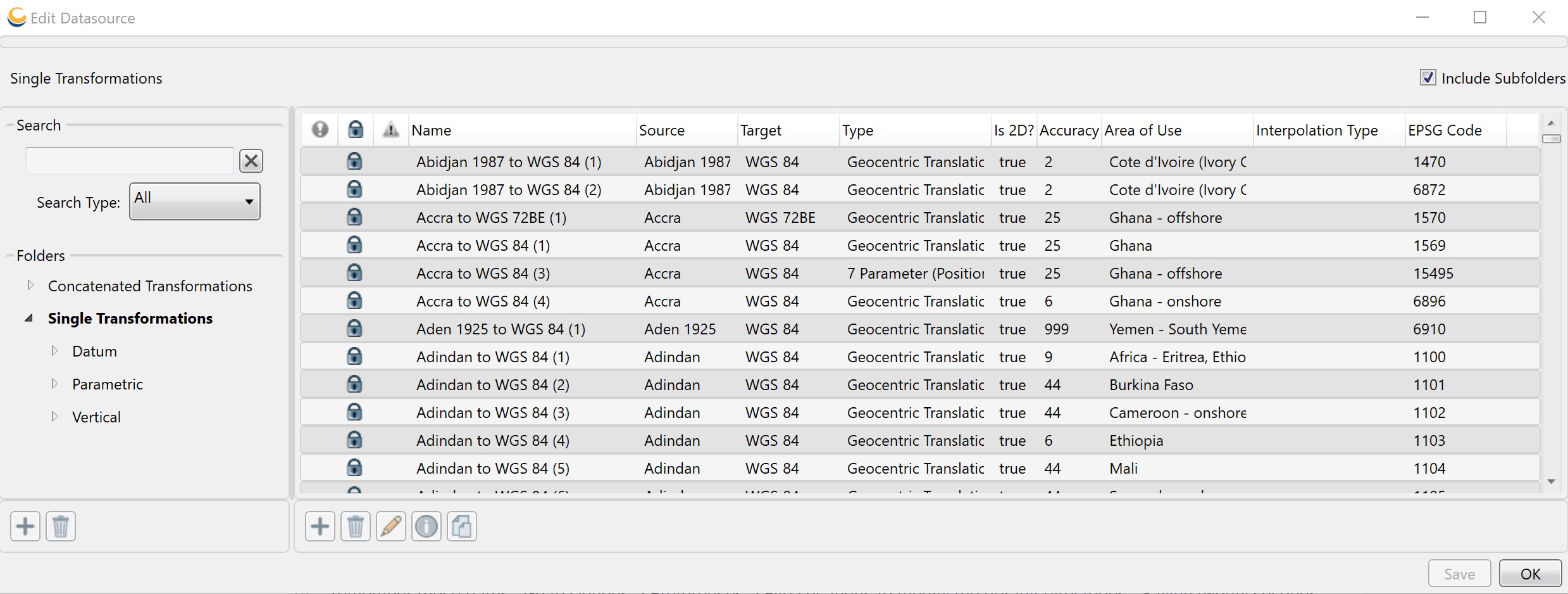
The Edit Datasource dialog allows you to add, change and delete user-defined Coordinate Transformations, and to view all Coordinate Transformations. You will have the option of viewing and editing Concatenated, Datum, Parametric, and Vertical Transformations.
Create a new Coordinate Transformation
-
Go to Datasource>Coordinate Transformation Definitions. An Edit Datasource dialog will open. You will have the option of viewing and editing Concatenated, Datum, Parametric, and Vertical Transformations.

-
Right-click in the right-hand pane and select New Object, or click the Add (+) button below the pane. A new blank Coordinate Transformation Editor dialog will open, based on the currently selected folder type (Concatenated, Datum, Parametric, or Vertical). There are two tabs on all versions of the Coordinate Transformation Editor:
Identification
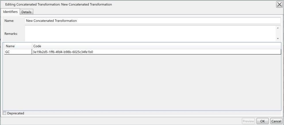
The Identification tab is used to name the object and associate identifying codes with it (if applicable).
- The Name field is where you need to enter the appropriate name for the definition, the name entered is the name that will be used to select the object in the main list.
- The Remarks field can be used to add notes on a definition and is optional.
- The Identifiers list may be used to add identifying codes for an object that may be referenced in other databases. The GC code is a unique identifier assigned by the Calculator; do not alter this code. To enter additional codes use the space below.
- Deprecated
may be checked to indicate an object is no longer being used, either
because there are errors in the definition, or because it has been
superseded by another object. If this is checked, you will be provided
with a date picker to set the date on which the object was deprecated.
This will default to the current date.

Coordinate Transformations additionally have an Accuracy field, to allow the user to set a known numerical accuracy value. Datum Transformations from EPSG have been updated to include the accuracy values specified in the EPSG dataset. Accuracy may be used to sort when Selecting a Coordinate Transformation for a conversion.
Details
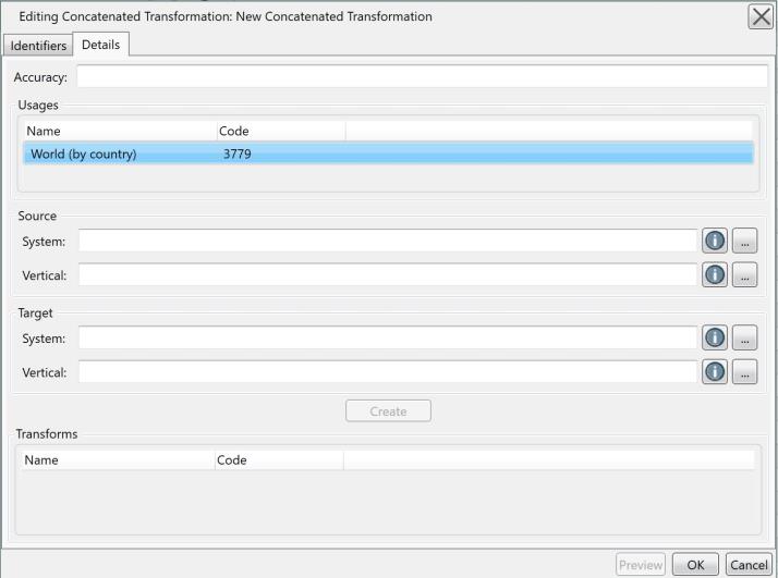
The Details tab is used to define the object's parameters. For all Coordinate Transformations, you must select an appropriate Usage definition. If you are unsure of a Usage definition to pick, leave it set to the default 'World.' The Source and Target fields are used to specify the Coordinate Systems the Transformation is valid for. Single Transformations (Datum, Parametric, Vertical) have a single Source and a single Target, while Concatenated Transforms may have a horizontal and vertical component for Source and Target. Single Transformations additionally specify a method appropriate to their type (Datum, Parametric, Vertical).
The Method specifies the necessary parameters to define a particular transformation. With the desired method selected, enter the appropriate parameters for your transformation in the table below. Be sure to define the appropriate units for each parameter by clicking the Units button.
Concatenated Transformations provide a means to chain together multiple Single Transformations, using a version of the Coordinate Transformation Picker dialog that is launched by clicking the 'Create' button. The individual Single Transformations are displayed in the table at the bottom of the Definition Panel.

 Grid Method Transformations
When creating a new transformation with a grid shift file method, the difference file should be placed in the data path directory. The default data path is C:\ProgramData\Blue Marble Geographics\Geographic Calculator\DataSource\shiftfiles
The data path will be specified in File Location PreferencesThis will allow you to only specify the grid file name when defining the transformation.
For a grid method custom vertical transformation, place the difference shift file in the vertical folder within the data path directory. This will allow you to specify the path to the grid file as vertical\ followed by the grid file name when defining the transformation.
Full file paths for shift files may not exceed 255 characters. If a file path is too long, the file will no be read and following error will be reported when you click OK to create the transformation.

-
Click OK to close the Coordinate/Datum Transformation Editor.
-
To save the definition permanently, click the Save button on the right hand side of the Edit Data Source dialog.
-
Click OK to close the Edit Datasource dialog, your new definition is complete and may be used within the Calculator.
Change an existing Coordinate Transformation
-
Go to Datasource>Coordinate Transformation Definitions. An Edit Data Source dialog will open.
-
Select the object from the Coordinate Transformation list.
Note: You can only edit objects shown in blue.
-
Double click the object you want to edit to open its definition.
-
Change any of the values and press the OK button.
-
To save the definition permanently, click the Save button on the right hand side of the Edit Data Source dialog.
Delete an existing Coordinate Transformation
-
Go to Datasource>Coordinate Transformation Definitions. An Edit Data Source dialog will open.
-
Select the object from the Coordinate Transformation list.
Note: You can only delete objects shown in blue. If you want to hide other objects from the datasource view, see Datasource Filters.
-
Select the object, right-click it and select Delete Object or click the Trash Can button below the object list.
-
To save the deletion permanently, click the Save button on the right hand side of the Edit Data Source dialog.
Download missing Coordinate Transformations
-
Go to Datasource> Coordinate Transformation Definitions. An Edit Data Source dialog will open.
-
Select the missing object from the Transformations list.
Note: Missing objects are shown in red with a red ! at the beginning of the entry.
-
Select the object, right-click it and select Download Missing Files.
-
If the Files are freely available then they will be automatically downloaded and installed.
Note: For more detail view Download Missing Datasource Entries