DLS (Dominion Land Survey)
The Dominion Land Survey (DLS) is a surveying system used in parts of Western Canada including the Alberta Township System (ATS) and Saskatchewan.
In the Geographic Calculator, DLS is supported using a string-based Point Style. There are two types of DLS point styles: one calculates offsets from the section corner, the other from the section boundary. The Boundary Measurement and Corner Measurement styles are listed as separate coordinate systems in the datasource.
Rather than entering in Latitude and Longitude, the user provides a number of values that are used to compose an DLS string. When a coordinate reference system with an DLS point style is chosen, the Coordinate Point Definition display will provide fields for the entry of these values:
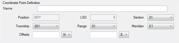
In all cases where the Legal Subdivision is displayed, the value is interpolated. Note that an input DLS coordinate may have its LSD parameter corrected after this calculation. All measurements are taken from the Section corner point, or the Section boundary.
If the Job is printed, the DLS coordinate will be printed as a string using the currently chosen String Display Order as specified in the DLS Format. In the case of the above, for example, the printed string using Unique Well Identifier ordering would be:
BDY 04 18 035 07 W5 325.03 N 193.58 E