Installing and Configuring the Network License
- Part I - Installing the Network Server Software
- Part II - Configuring the Network Service
- Part III - Settings File Distribution
- Appendix A - Sharing the Settings.XML, Data Source, and Vertical Height Files
Important Note:
Part I and Part II provide instructions on how to install the FLEXnet 11.15 license server software, which is separate from the steps required to install the network licensing components for Geographic Calculator software on the user's machine in PART III.
You can configure Geographic Calculator so that all of the users share common settings and a common data source file. In order to share a set of common settings and data source files across the network, you must do one of the following:
- Perform an installation of Geographic Calculator on a server machine and share the folders from here.
- Perform the installation on a client machine and share the folders from this client; this machine must always be available on the network in order for clients to access the files.
- Perform the installation on a client machine, and then copy the folders to shared folders on a server machine for distribution after initial configuration.
To complete a shared network file configuration, please follow the steps in Appendix A - Sharing the Settings.XML, Data Source, and Vertical Height Files when you come to them in Part III. Otherwise, you may omit these instructions from your installation.
Part I - Installing the Network Server Software
-
Upon purchase of a network license of Geographic Calculator, you will receive an e-mail with instructions to download a ZIP file containing FLEXnet 11.15 and a signed settings file.
-
Verify that ports 27000-27010 on your chosen FLEXnet license server are not blocked by any routers, firewalls, or other hardware or software security measures. Please contact your network administrator if you are not sure about this step.
-
Unzip the FLEXnet 11.15 folder to your chosen FLEXnet license server. We recommend that you do NOT run the Geographic Calculator from a FLEXnet server machine.
Note: To avoid configuration problems, FLEXnet recommends that you keep the path to the FLEXnet11.15 folder as short and simple as possible.
-
Open the LMTOOLS.EXE application in the FLEXnet11.15 folder. You will find this program in the selection of files you just extracted on the server (Figure 1).
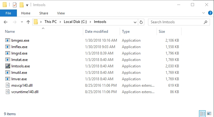
Figure 1. Run lmtools.exe from the directory on your application server.
-
On the Service/License File tab of LMTools (Figure 2), select the 'Configuration using Services' radio button.
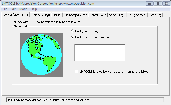
Figure 2. Select the Configuration using Services radio button option. -
Click on the System Settings tab of LMTools (Figure 3).
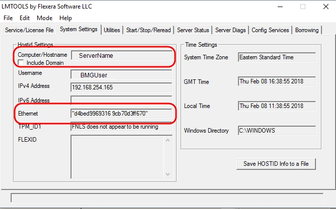
Figure 3. Clicking the System Settings tab opens the dialog shown above. -
In the 'HostId Settings' section of the System Settings tab, you will see fields labeled 'Computer/Hostname', 'IP Address', and 'Ethernet Address'. You must report the 'Ethernet Address' AND the 'IP Address' OR 'Computer/Hostname' to Blue Marble Geographics via e-mail at authorize@bluemarblegeo.com or by phone.
NOTE: Please do NOT use IP Address if your FLEXnet server does not have a fixed IP address (typical if you are on a DHCP network.)
IMPORTANT: If using a laptop with a docking station, you must activate the software in the undocked state. If you have both wireless and fixed NICs, please disable the wireless/NIC temporarily before activating the software and then activate using a wired connection.
-
Once the FLEXnet server information has been received, Blue Marble Geographics will supply you with a secure, custom license file.
Part II - Configuring the Network Service
Once you have received the GeographicCalculator.lic license file from Blue Marble Geographics, please complete the following steps:
-
Please place your GeographicCalculator.lic license file in the directory on the server from which the network service will run (where you put the contents of the .zip file in Part I Step 1) as shown in Figure 4.
Figure 4. Place the license file in the network service directory on your application server. -
Now that the license file is installed, you can start the license server. Run the LMTOOLS.EXE program from the server
-
Click on the Config Services tab of LMTools (Figure 5).
-
Fill in the 'Service Name' field with a meaningful name of your choice, such as 'CalculatorService' or 'BMGCalculator'.
-
Set 'Path to the lmgrd.exe file' to reflect the path to the directory on the server from which the network service will run.
-
Set the 'Path to the license file' to the same directory.
-
Set the 'Path to the debug log file' to the directory where you want the system to write the log file. Don't forget to specify a file name for the log file as part of the 'Path to the debug log field' field.
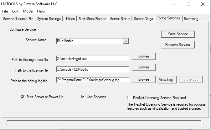
Figure 5. Fill in the required parameters to configure the service. -
If you want the license server to run as a Windows Service (recommended), check the 'Use services' check box. This will enable the 'Start Server at Power Up' check box (Figure 6). Check this if you want the service to start when the server is turned on or rebooted.
-
Click the 'Save Service' button to store your settings for the service.
-
You are now ready to start the license server. Click the Start/Stop/Reread tab of LMTools (Figure 7).
-
Click on 'Start Server' to run the license server service. The status line at the bottom of the dialog (Figure 7) should read "Server Start Successful".
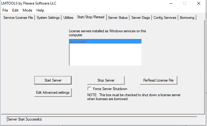
Figure 7. The Start/Stop/Reread tab after a successful server start -
To stop the server at any time, simply click on the Stop Server button. You must check 'Force Server Shutdown' to stop the server when BORROW licenses are checked out.
Part III - Settings File Distribution
-
Install the Geographic Calculator application to the FLEXnet server or a client PC (please see IMPORTANT NOTE at the preface of this document.)
-
Move your settings_64_2019SP1.xml file to a secure location for safekeeping, and make a copy of the file.
-
Rename the copy of the settings_64_2019SP1.xml file as settings.xml. Create a shared network folder and move settings.xml to that folder (Figure 8).
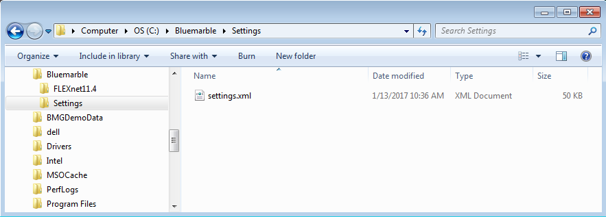
Figure 8. Rename the settings_64_2019SP1.xml file to settings.xml. -
Please read APPENDIX A if you want to modify the envelope filters, settings, and data source settings for the work group, and/or lock the settings with an Administrative password. If not, please skip to Step 5.
-
Send the settings.xml file out to all users, having them save it to the following location: 'C:\ProgramData\Blue Marble Geographics\Geographic Calculator folder' (Figure 9).
Note: The 'ProgramData' folder may be hidden. To View, select Organize> Folder and Search Options> View> Show hidden files and folders.
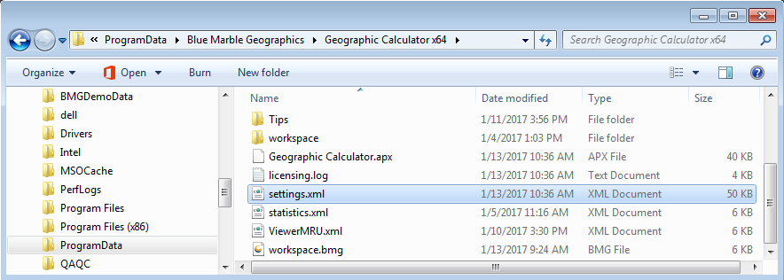
Figure 9. Rename the settings_64_2019SP1.xml file to settings.xml.
-
Alternatively, you can rename the settings_64_2019SP1.xml file as settings.xml and put a copy of your settings.xml file in the shared network folder you created in Part III Step 3.
-
Refer to Connecting to a Network License Server to connect Geographic Calculator to the newly created License Server
Appendix A - Sharing the Settings.XML, Data Source, and Vertical Height Files
-
Open the Geographic Calculator application.
-
Geographic Calculator will automatically open the License Manager if it detects the application is unregistered.
-
Click OK to close this box if it opens.
-
From the Menu Bar, click Options -> Administrative Settings.
-
Make the Administrative settings changes you want on the Administrative and Filtering tabs and click OK (Figure 10).
Note: You must enter a password and check the box Administrative lockdown active to secure the settings from future changes.
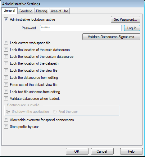
Figure 10. Modify your Administrative Settings.IMPORTANT NOTE: You must make all of your changes before pushing out or distributing the settings.xml file. If you make any changes to settings.xml after distribution, you must repush/redistribute in order for the changes to perpetuate throughout the network.
Once you have installed and configured Geographic Calculator and your required vertical height files on the server, you can configure the clients to share these files in your work group:
-
Copy the DATA folder and all of its contents and subdirectories from your Geographic Calculator application to the shared folder on your network.
Note: Any vertical reference files you require for conversions must be installed to the \DATA\VERTICAL folder on the shared network folder.
You can download these files from:
http://www.bluemarblegeo.com/products/geographic-calculator-download.php -
Verify that all of the Geographic Calculator application users have Full Control rights to shared application files.
-
Open the Geographic Calculator application and click Options -> Preferences from the Menu Bar.
-
On the File Locations tab, set the 'Datasource' path for the 'Main Datasource' to the geodata.xml file in your shared DATA folder (Figure 11).
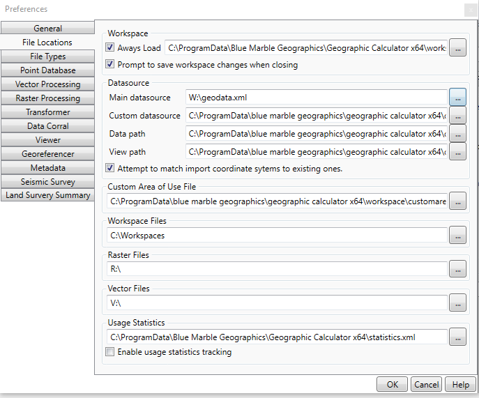
Figure 11. The File Locations tab.
